
Page 132 - TINA Dergi Sayi 10
P. 132
TINA
Denizcilik Arkeolojisi Dergisi
Fig.7: Dalgakıranlarda tespit edilen
Amphoralar.
Fig.7: The amphoras identified at
breakwaters.
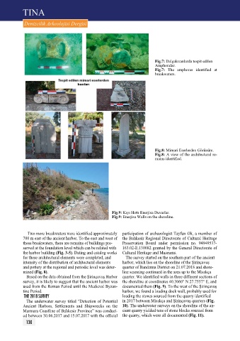
Fig.8: Mimari Eserlerden Görünüm.
Fig.8: A view of the architectural re-
mains identified.
Fig.9: Kıyı Hattı Enerjisa Duvarlar.
Fig.9: Enerjisa Walls on the shoreline.
Two more breakwaters were identified approximately participation of archaeologist Tayfun Ok, a member of
700 m east of the ancient harbor. To the east and west of the Balıkesir Regional Directorate of Cultural Heritage
these breakwaters, there are remains of buildings pre- preservation Board under permission no. 94949537-
served at the foundation level which can be related with 163.02-E.130082 granted by the General Directorate of
the harbor building (Fig. 3-5). Dating and catalog works Cultural Heritage and Museums.
for these architectural elements were completed, and The survey started on the southern part of the ancient
intensity of the distribution of architectural elements harbor, which lies on the shoreline of the Şirinçavuş
and pottery at the regional and periodic level was deter- quarter of Bandırma District on 21.07.2018 and shore-
mined (Fig. 8). line scanning continued in the area up to the Misakça
Based on the data obtained from the Şirinçavuş Harbor quarter. We identified walls in three different sections of
survey, it is likely to suggest that the ancient harbor was the shoreline at coordinates 40.3060° N 27.7557° E, and
used from the Roman period until the Medieval Byzan- documented them (Fig. 9). To the west of the Şirinçavuş
tine period. harbor, we found a loading dock wall, probably used for
tHe 2018 SurVeY loading the stones sourced from the quarry identified
The underwater survey titled “Detection of potential in 2017 between Misakça and Şirinçavuş quarters (Fig.
Ancient Harbors, Settlements and Shipwrecks on the 10). The underwater surveys on the shoreline of the an-
Marmara Coastline of Balıkesir province” was conduct- cient quarry yielded tens of stone blocks sourced from
ed between 30.06.2017 and 15.07.2017 with the official the quarry, which were all documented (Fig. 11).
130