
Page 102 - TINA Dergi Sayi 09
P. 102
TINA
Denizcilik Arkeolojisi Dergisi
Erdemli Kızkalesi Paşatürbesi Cape: We conduct- cak Cape. The METU diving group performed a study in
ed scuba diving and skin diving for exploration as well Yılanlıada 18 years ago together with prof. Dr. Levent
as sonar scanning. The seabed is completely sandy. No Zoroğlu, and found a shipwreck and numerous anchors .
2
remains were detected because the archaeological arte- We surveyed the same area, and examined current status
facts remain probably buried under this layer of depos- of the artefacts. They still had their labels. No survey
its. We made a seabed scan starting from the western was conducted in the Aydıncık Kelenderis Harbour and
shore of the cape until the tower, which rises to the east the area where the ancient city of Kelenderis occupied.
of the ancient city of Korykos. In 2016, we studied the The harbour and shores were excavated and surveyed by
area to the west of the site, and found that the entire site Hakan Öniz and his team under the direction of Levent
was covered with a sandy floor. Zoroğlu between 2004 and 2007, and a harbor launch
Eastern Cape of Silifke Narlıkuyu: The scuba dives was detected inside the harbour . Other than this, we ex-
3
here revealed some ballast stones probably belonging to amined the area in front of the Gilindere Cave lying to
a shipwreck on the western shore of the natural harbour the east of the Sancak Cape, and detected no remains.
area. The seabed is completely sandy in this natural har- The Sancak Cape has an important archaeological po-
bour area, and no remains were observed here. We also tential with three shipwrecks discovered in this region.
conducted a sonar scan, with no evidence of any archae- There are remains of two shipwrecks with a cargo of
ological form. amphoras, and one ship-
The vicinity and op- Fig. 8 wreck with a cargo of
posite shores of Silifke plates.
Dana Island: We dived Bozyazı: Two sites
around the Dana Island have been studied in
and the lighthouse near- this region. The first
by, and checked the cur- one is the Tekeli Ak-
rent physical status of the saz Island. The survey
shipwrecks discovered yielded numerous stone
in 2015. Several remains and iron anchors and
were detected during the stone stocks for wood-
dives conducted in the en anchors. These an-
Mavikent-Jandarma Bay chors are mainly dated
across the island. Some of to the Bronze and Iron
these remains may belong Ages. Thus, it indicates
to a shipwreck. that this small island
Silifke Taşucu Harbour functioned as a port of
Castle Bay: We conducted sonar scanning and dives refuge for long-distance ships of the period. The other
for two days in the bay housing a castle from the Ot- site is the Kızıl Cape. We explored the bays both to the
toman period. The seafloor is completely sandy. We east and west of the cape, and found no remains. The
found some pottery fragments on the southern part of southern part was not explored. Several artefacts were
the harbour. Inside the harbour, we detected a sunken found in the area of Toylaklar Bay on the west. They
ship, which probably struck the shore during a storm should have belonged to a shipwreck. However, due to
and completely fell apart. Furthermore, we found two lack of evidence, it is not considered a shipwreck.
iron anchors and amphora fragments dating to the Iron Anamur: Two sites have been studied in this region.
Age on the southern shore outside the harbour, which The Melleç-Demirören shoreline was also surveyed in
are probably related with the shipwreck. 2016. In 2017, we examined the previously discovered
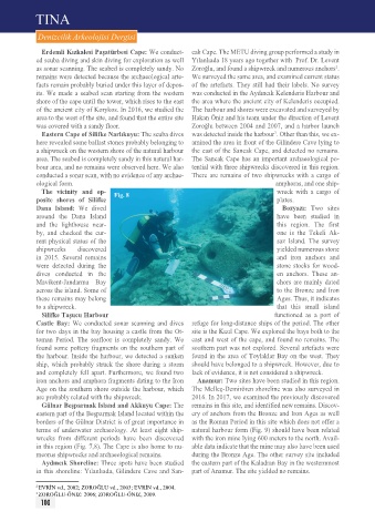
Gülnar Beşparmak Island and Akkuyu Cape: The remains in this site, and identified new remains. Discov-
eastern part of the Beşparmak Island located within the ery of anchors from the Bronze and Iron Ages as well
borders of the Gülnar District is of great importance in as the Roman period in this site which does not offer a
terms of underwater archaeology. At least eight ship- natural harbour form (Fig. 9) should have been related
wrecks from different periods have been discovered with the iron mine lying 600 meters to the north. Avail-
in this region (Fig. 7,8). The Cape is also home to nu- able data indicate that the mine may also have been used
meorus shipwrecks and archaeological remains. during the Bronze Age. The other survey site included
Aydıncık Shoreline: Three spots have been studied the eastern part of the Kaladran Bay in the westernmost
in this shoreline: Yılanlıada, Gilindere Cave and San- part of Anamur. The site yielded no remains.
2 EVrİN vd., 2002; ZOrOĞLU vd., 2003; EVrİN vd., 2004.
3 ZOrOĞLU-ÖNIZ: 2006; ZOrOĞLU-ÖNIZ, 2009.
100