
Page 80 - TINA Dergi Sayi 09
P. 80
TINA
Denizcilik Arkeolojisi Dergisi
Buzul-hidro-izostasi denilen bu dengeleme olurken, This equilibrium, the so-called glacio-hydro-iso-
aynı zamanda tektonik olarak hareketli kıyı bölgele- static adjustment, occurred simultaneously as the
rinde, yerkabuğu depremlere bağlı olarak düşey yönde Earth’s crust moved vertically in the tectonically
hareket etti ve bazı bölgelerde çökmeler, bazı bölgeler- active coastal regions, resulting in subsidence or
de ise yükselmeler gerçekleşti . Küresel deniz seviyesi uplifting in some regions, depending on the earth-
2
yükselimi ve düşey tektonik hareketlerin yanı sıra, se- quakes . In addition to the global sea level rise and
2
dimantasyon da kıyı şeridini değiştiren faktörlerden bi- vertical tectonic movements, sedimentation was
risini oluşturdu. Moore ve Hillman , Neolitik dönemin also one of the factors that changed the coastline.
3
başlangıcının Younger Dryas denilen soğuk ve kurak Moore and Hillman have suggest that the be-
4
3
dönemin (günümüzden 11-10 bin yıl önce) sonuna ginning of the Neolithic period coincides with
denk geldiğini, Neolitik yerleşimlerin çoğunlukla tarım the end of Younger Dryas, a cold and dry period
4
için uygun alanlara kurulduğunu ifade etmektedir. (11,000-10,000 BP) during which Neolithic set-
Fischer’e göre ise Mezolitik dönem yerleşimleri, tlements were established mostly in areas suitable
5
olasılıkla nehir ağızları, küçük adalar ve yarımadalar for agriculture. On the other hand, Fischer argues
5
gibi balıkçılık için en uygun kıyılara kurulmuştur. Eski that the Mesolithic settlements were more likely to
çağlarda insanlar gerek besine ulaşmak için, gerekse have been established in the suitable coastal areas
su ihtiyacını karşılamak için akarsuların denize karış- for fishing, such as river mouths, small islands, and
tığı deniz kıyılarına yerleşmiş olmalıydı. Söz konusu peninsulas. In order to reach to both food and water
kıyı yerleşim alanları ise, deniz seviyesinin yükselmesi supply, people would settle at the river deltas in an-
sonucu günümüzde sular altında bulunmakta olup, bu cient times. Today, such coastal sites are submerged
alanları araştırmak son yıllarla oldukça popüler bir dal as a result of sea level rise, and recently they have
haline gelmiştir. become a popular research subject.
2 LAMBECK vd. 2014, 15296. 2 LAMBECK et al 2014, 15296.
3 MOOrE-HILLMAN 1992, 482. 3 MOOrE-HILLMAN 1992, 482.
4 Younger Dryas olayı, günümüzden 11-10 bin yıl önce son buzul 4 The Younger Dryas event is a cold and dry climatic interval
döneminden buzularası döneme geçiş evresinde yaşanan soğuk ve during the transition from the last glacial maximum to the
kurak iklim aralığıdır (FAIrBANKS 1989). interglacial age 11,000-10,000 BP (FAIrBANKS 1989).
5 FISHEr 1995, 371. 5 FISHEr 1995, 371.
Sea level (m)
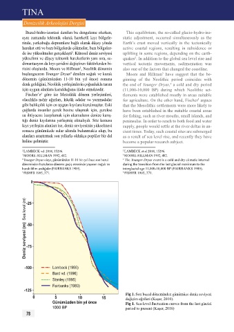
Fig 1. Son buzul döneminden günümüze deniz seviyesi
değişim eğrileri (Kaşer, 2010).
Fig 1. Sea-level fluctuation curves from the last glacial
1000 BP period to present (Kaşer, 2010)
78