
Page 84 - TINA Dergi Sayi 09
P. 84
TINA
Denizcilik Arkeolojisi Dergisi
metHODOLOGY od to the present can be observed, and inundated areas
The research strategy that used for the exploration of can be identified. However, global sea level change
submerged Neolithic settlements includes: (i) identifi- should not be considered the only parameter in studies
cation of the paleogeography, assessment of the archae- for Neolithic settlements in tectonically active regions;
ological potential in the area, and mapping of the area the results of tectonic subsidence rates from the local
to be surveyed; (ii) use of geophysical remote sensing studies should also be assessed. Then, the relationship
techniques for high resolution imaging of the seafloor between the sea and ancient land settlements in the vi-
and bottom; (iii) visualization of potential areas identi- cinity needs to be established. Present-day topography
fied by interpretation of geophysical data using robotic should be examined to locate river beds and their possi-
cameras or divers, and (iv) radiocarbon dating of de- ble paleo-mouths. The location of paleo-riverbeds and
tected finds. A multidisciplinary study and survey of coastlines can be investigated by marine seismic and
potential submerged Neolithic settlements must be car- multi-beam bathymetric methods. This allows identi-
ried out by a collaboration of several discipline, such fication of potential sites, and helps narrow down the
as marine geophysics, geology, and geography, as well areas to be surveyed.
as archaeology. The second phase involves identification of buried
The ancient coastline must be mapped using sea lev- structures, again using high resolution marine seismic
el change curves to determine paleogeography, so that method. The seafloor can be imaged acoustically by a
the evolution of the shoreline from the Neolithic peri- side-scan sonar to detect visible remains of settlements.
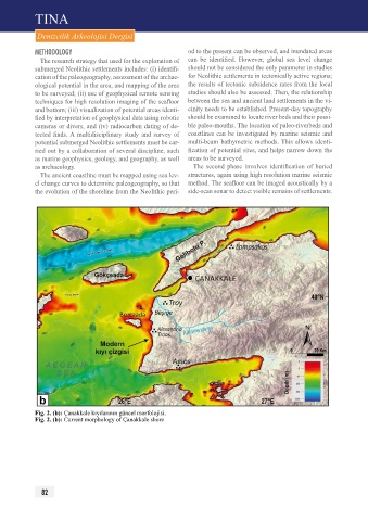
Fig. 2. (b): Çanakkale kıyılarının güncel morfolojisi.
Fig. 2. (b): Current morphology of Çanakkale shore
82