
Page 41 - TINA Dergi Sayi 12
P. 41
TINA
Maritime Archaeology Periodical
HOw tO LOCAte SeA LeVeL? the actual sea level a couple of times a day and calculate
the local high tide from these data. The best would be the
Global sea level has about a 1 m tidal range. In the installation of a temporary tidal gauge to account for any
microtidal Mediterranean, it is significantly less, from local effect along a dissected shoreline.
20 cm upwards . In places, especially in embayments,
1
tidal range is up to 1 m (e.g. in the Gulf of Trieste). Mi- wHICH ArCHAeOLOGICAL ObJeCtS CAn be beSt reLAteD tO SeA LeVeL?
crotidal seas allow direct measurement of elevation or The functional height of archaeological installations
depth of archaeological installations relative to sea level determines their relative usefulness in determining the
at any time of the day. An appropriately protected spot amount of coastal uplift or subsidence relative to sea lev-
8
in the sea must be selected, with as little wave action as el . Structures now in emerged position, originally built
possible, and the midpoint elevation between low and for underwater use, mark coastal uplift. Their functional
high waves ascertained, marked, and measured. Under height (e.g. the original minimum elevation of the walk-
a higher tidal range system, one might want to measure way on a quay) is best determined by an archaeologist.
7 EVELPIDOU et al. 2012.
8 MORHANGE-MARRINER 2015.
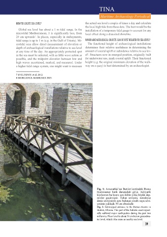
fig. 1: Arnavutluk’un Butrint kentindeki Roma
tiyatrosunun batık durumdaki girişi. Adriyatik
kıyılarının bu kısmı son ikibin yılda büyük dep-
remler geçirmiştir. Taban seviyesi, neredeyse
deniz seviyesiyle aynı bulunan yeraltı suyu sevi-
yesinin yaklaşık 30 cm altındadır.
Fig. 1: Submerged entrance to the Roman theatre in
Butrint, Albania. This part of the Adriatic coast repeat-
edly suffered major earthquakes during tha past two
millennia. Floor level is about 30 cm below groundwa-
ter level, which i the same as nearby sea level.
39