
Page 43 - TINA Dergi Sayi 12
P. 43
TINA
Maritime Archaeology Periodical
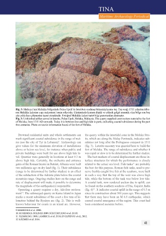
fig. 3: Malezya’nın Malakka bölgesinde pulau Upeh’de lateritten oyulmuş bitmemiş kesme taş. Taş ocağı 1511 yılından itiba-
ren Malakka kalesine yapı malzemesi temin ediyordu. Günümüzde kısmen düşük ve yüksek gelgit arasında olan bölge son beş
yüz yılda kıyı çökmesine işaret etmektedir. Fotoğraf Malakka kalesi turist bilgi panosundan alınmıştır.
Fig. 3: Unfinished ashlar carved in laterite, Pulau Upeh, Melaka, Malaysia. The quarry supplied construction material to the fort
of Melaka, from 1511 AD onwards. Today it is between low and high tide in parts, indicating coastal subsidence during the past
five centuries. Photo on tourist information board of the fort of Melaka.
Drowned residential units and whole settlements can the quarry within the intertidal zone in the Melaka Stra-
mark significant coastal subsidence in the range of met- its, which are along the Malay peninsula, indicates sub-
9
res (see the city of Tyr in Lebanon) . Archaeology can sidence not long after the portuguese conquest in 1511
give values for the minimum elevation of installations (fig. 3). Laterite masonry was quarried here to build the
above or below sea level, for instance when public and fort of Melaka. The range of subsidence and whether it
private buildings were built for use above high tide le- was rapid or slow is to be determined by further studies.
vel. Quarries were generally in locations at least 0.3 m The best markers of coastal displacement are those in-
above high tide. Certainly, the orchestra and entrance terface structures for which the performance is closely
gates of the Roman theatre in Butrint, Albania were built related to the actual sea level. Fish tanks are probably
11
two millennia ago on dry land (fig. 1). Their subsidence the best for this purpose. Roman fish tanks, used to pre-
(range to be determined by further studies) is an effect serve freshly-caught live fish at the seashore, were built
of the subduction of the Adriatic plate below the coastal in such a way that the top of the weir was above high
mountain range. Ongoing studies here on the range and tide, while the bottom of the tank was below low tide.
rate of displacement will make it possible to determine A coastal tank, now rendered useless due to uplift, can
the magnitude of the earthquake(s) responsible. be found on the southern seashore of Diu, Gujarat, India
Operating a quarry requires a dry, tide-free environ- (fig. 4) . It indicates coastal uplift in the range of 0.5 m
12
10
ment . The submerged quarry on Kume Island in Japan since its construction about 500 years ago. This suggests
marks a recent subsidence of the coast a few tens of ki- that there may have been an M 6.8 earthquake, which
lometres behind the Ryukyu arc (fig. 2). This is well- caused coastal emergence of the region. This coast had
known behaviour for coasts in an island arc. However, been considered aseismic before.
9 MARRINER et al. 2008.
10 AURIEMMA-SOLINAS 2009, SCICCHITANO et al. 2018).
11 FLEMMING 1969; LAMBECK et al. 2010; EVELPIDOU et al., 2012.
12 KÁZMÉR et al. 2016.
41