
Page 21 - TINA Dergi Sayi 09
P. 21
TINA
Maritime Archaeology Periodical
The fact that fishing is an activity that requires Although the likelihood of a submerged settlement is
knowledge, experience, and use of tactics suggests presently being investigated, it is very unlikely that such
that the Tatlısu-Çiftlikdüzü community likely arrived remains have survived to the present due to rough and
from a coastal settlement on the opposite shore, who turbulent sea in this area.
were familiar with seafaring. This question can only On the northern coastline, settlements from the
be answered by systematic surveys and controlled Pre-Pottery and Pottery Neolithic periods are mostly
excavations on the southern coast of Turkey, as well located close to the shore. Among them are excavated
as identification of any early Neolithic period settle- sites, such as Petra tou Limniti (Yeşilırmak kayası),
28
ments that may have had a connection with Cyprus. Ayios Epiktitos-Vrysi (Fig. 9), Ayios Epiktitos-Troul-
GeOGrAPHIC DIStrIbutIOn OF neOLItHIC SettLementS In CYPruS li, Esentepe-Ağırsu (Fig. 10), Tatlısu-Çiftlikdüzü, and
Significant differences are evident between the south- Cape Andreas-Castros from west to east, and sites iden-
29
ern and the northern parts of the island in terms of the tified during surveys such as Küçük Erenköy-Villourin,
locations of the Neolithic settlements in Cyprus. Al- Tatlısu-Karaburun (Fig. 11), Tatlısu-Kuyu (Lakkous),
though this may be due to sites preferred for surveys Mersinlik-Pınarcıklar, and Karpaz-Kordhyli (Fig. 12).
and excavations, it is also supported by the density and These settlements are located at a distance of no more
distribution of known settlements. Aside from Nissi and than 10 meters from today’s shoreline and most have
Aetokremnos, all Neolithic settlements in the south of been exposed to partial erosion. Some are located at an
27
the island (such as Aspros, Ais Yorkis, Ortos, Klimonas, elevation of 15 m from sea level, with the cliffs and the
Tenta, Shillaourokambos, Khirokitia, Asprokremnos) sea below them. As part of the Tatlisu-Çiftlikdüzü proj-
are far from the sea (Fig. 5). Similarly Mylouthkia, lying ect, the plan is to conduct a survey of underwater Neo-
in the south of the island and dated to the Neolithic peri- lithic settlements on the northern coasts of Cyprus in the
od, is a hundred meters from the sea, but it is identified same way they were surveyed on Levantine coasts. If
only by its deep wells filled with refuse from a later date. positive results are obtained during this survey, it is clear
Until now a connection between these wells and a near- that the survey will provide a significant contribution to
by settlement has not been proven. both Cypriot prehistory and underwater archaeology.
27 These two sites have issues of stratigraphical defini-
27 These two sites have issues of stratigraphical definition. 28 The first systematic archaeological surveys were car-
tion. ried out on the island by the Swedish Cyprus Expedition Project
28 The first systematic archaeological surveys were carried out on the island by the Swedish Cyprus Expedition Project between 1927
between 1927 and 1931 under the leadership of architect john
and 1931 under the leadership of architect john Lindros and archaeologists Einer Gjerstad, Erik Sjoqvist, and Alfred Westholm.
29 ŞEVKETOĞLU 2000. Lindros and archaeologists Einer Gjerstad, Erik Sjögrist, and
29 ŞEVKETOĞLU 2000.
Alfred Westholm.
fig. 11: Tatlısu-Ka-
raburun’un genel gö-
rünümü, Kıbrıs. (Fo-
toğraf: Tatlısu Kazı
ve Araştırma Projesi
Arşivi).
fig. 11: A general
view of Tatlısu-Kara-
burun, Cyprus. (Pho-
tographic Archive of
the Excavation and
Survey Project in Tat-
lısu).
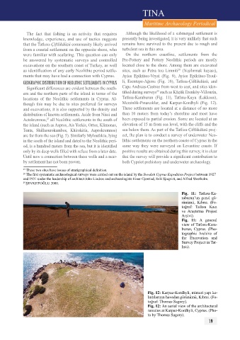
fig. 12: Karpaz-Kordhyli, mimari yapı ka-
lıntılarının havadan görünümü, Kıbrıs. (Fo-
toğraf: Thomas Sagory).
fig. 12: An aerial view of the architectural
remains at Karpaz-Kordhyli, Cyprus. (Pho-
to by Thomas Sagory).
19