Page 21 - TINA Dergi Sayi 12
P. 21

TINA


                                                                         Maritime Archaeology Periodical


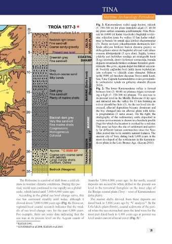
                                                                    Fig. 2: Karamenderes vadisi aşağı kesimi, yüksek
                                                                    (1: 250-300 m) bir plato önündeki alçak (2: 40-80
                                                                    m) plato sırtları arasında şekillenmiştir. Orta Holo-
                                                                    sen’de (6000 yıl kadar öncelerde) bugünkü seviye-
                                                                    sine yükselen deniz bu vadiye 15 km kadar sokul-
                                                                    muş ve burada bir ırmak ağzı körfezi oluşturmuştur
                                                                    (3). Deniz seviyesi yükselmesinin durmasıyla kör-
                                                                    fezde  alüvyon  birikimi  baskın  duruma  geçmiş  ve
                                                                    delta gelişim süreci ile bugünkü alüvyal vadi tabanı
                                                                    ovasına dönüşmüştür (3 aynı alan). Sağda, kırmızı
                                                                    yıldızla yeri belirtilen sondaja ait stratigrafik kesit
                                                                    (Log) üzerinde, deniz ilerlemesi sonrasında, burada
                                                                    değişen ortamlarda biriken sediman birimleri göste-
                                                                    rilmiştir. Bu çevre, uygun doğal özellikleri sayesin-
                                                                    de Neolitik çağlardan beri farklı insan toplulukları
                                                                    için  yerleşme  ve  etkinlik  alanı  olmuştur.  Bilinen
                                                                    tarihi 5000 yıl öncelere dayanan Troya antik kenti,
                                                                    Geç Tunç Çağında Karamenderes ovası çevresinde-
                                                                    ki yerleşmeler içinde en gelişmiş olanıdır (Kayan
                                                                    2014).
                                                                    Fig. 2: The lower Karamenderes valley is formed
                                                                    between low (2: 40-80 m) plateau ridges surround-
                                                                    ing a high (1: 250-300 m) plateau. The sea rose to
                                                                    its present level in the Middle Holocene (6 ky ago)
                                                                    and intruded into the valley for 15 km forming an
                                                                    a river-mouth bay here (3). As the sea level rise de-
                                                                    creased, alluvial deposition became dominant and
                                                                    the bay changed into an alluvial plain with delta-
                                                                    ic  progradation  (3  same  areas).  On  the  right,  the
                                                                    stratigraphy of the sedimentary units deposited in
                                                                    various environments is shown in a borehole profile
                                                                    (log) for which the location is marked by a red star.
                                                                    This area has been the site of settlement and activi-
                                                                    ty for different human communities since the Neo-
                                                                    lithic period due to its suitable natural features. The
                                                                    ancient city of Troy, dating back 5,000 years, is the
                                                                    most developed of the settlements in the Karamen-
                                                                    deres plain in the Late Bronze Age. (Kayan 2014).


               The Holocene is a period of shift from a cold cli-  Anatolia 7,000-6,000 years ago. In the north, coastal
            mate to warmer climatic conditions. During this pe-  deposits are accessible when drilled to the present sea
            riod, world seas continued to rise rapidly on a global   level in the terrestrial foot-plain on the inner edge of
            scale, which lasted until 7,000-6,000 years ago.   the Beşige coastal plain (Troy – west of Karamenderes
              According to the global sea level change curve, this   delta plain).
            rise  has  continued  steadily  until  today,  although  it   The  marine  shells  derived  from  these  deposits  are
            slowed down 7,000-6,000 years ago (Fig. 4). However,   dated back to 5,800 years ago by  C analysis . In the
                                                                                                     10
                                                                                           14
            regional-local coastal research indicates that the mod-  Urla İskele plain (İzmir), coastal sediments of the peri-
            els of sea level change vary for the past 6,000 years.   od when the sea encroached upon the land were for the
            For example, there are some data indicating that the   most part dated back to 4,400 years ago at present sea
            sea  was  at  its  present  level  on  the Aegean  coasts  of   level under current alluvial cover (Fig. 5) .
                                                                                                 11
            10  KAYAN 1991.
            11  GOODMAN et al 2008, KAYAN et al 2019.
                                                                                                         19
   16   17   18   19   20   21   22   23   24   25   26